Mumbai Red Alert: Extreme Rainfall Hits City Today
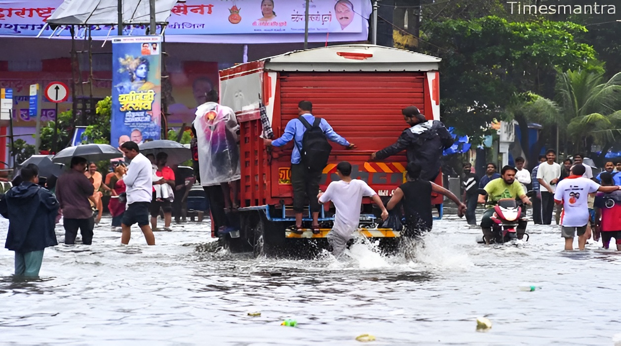
Mumbai, September 28, 2025 – Mumbai, the bustling financial capital of India, is under a severe red alert as extreme rainfall batters the city today, unleashing torrents that have already paralyzed transportation, flooded low-lying areas, and prompted widespread evacuations. The India Meteorological Department (IMD) has forecasted 150-200 mm of rain in the next 24 hours, with isolated pockets in the western suburbs like Andheri, Bandra, and Dadar facing even heavier downpours of up to 250 mm. Winds gusting at 50-60 km/h from the Arabian Sea are compounding the chaos, uprooting trees, toppling billboards, and causing power outages across 40% of the Mumbai Metropolitan Region (MMR). Temperatures have plummeted to 24°C from yesterday’s 34°C, with humidity soaring to 92%, creating a muggy mayhem that has grounded flights at Chhatrapati Shivaji Maharaj International Airport (CSMIA) and halted local trains on the Western and Central lines. Chief Minister Eknath Shinde, chairing an emergency virtual meeting from the Mantralaya at 8:00 AM, declared, “Mumbai’s spirit is unbreakable, but we must act swiftly to protect lives—NDRF teams are deployed, and all essential services are on high alert.” This deluge, the heaviest since the catastrophic July 26, 2005, floods that claimed 1,094 lives, coincides with a low-pressure system over the Lakshadweep region intensifying into a depression, threatening to evolve into a cyclonic storm by tomorrow. As water levels in the Mithi River rise 2 meters and 50,000 residents in Dharavi and BKC are evacuated, September 28 marks not just a weather event but a wake-up call for urban resilience in a city of 21 million where concrete jungles clash with climate’s fury. With IMD’s Doppler radar at Colaba tracking the system’s northwest trajectory at 12 km/h, this red alert isn’t a warning—it’s a watershed, demanding immediate action to avert a tragedy in the Maximum City.
The IMD’s bulletin, issued at 5:00 AM today, delineates a dire deluge: A cyclonic circulation over the southeast Arabian Sea has deepened into a depression, barreling northwest at 12 km/h toward Mumbai’s coast, likely crossing between Daman and Alibag by evening. Red alerts—the highest in IMD’s color-coded hierarchy—blanket Mumbai, Thane, Palghar, and Raigad, projecting 150-200 mm rainfall and gales up to 60 km/h, a scenario primed for urban inundation and coastal surges. Orange warnings cascade to 8 more districts, including Pune and Nashik, anticipating 64.5-115.5 mm, while yellow cautions cloak the Konkan, expecting 34.5-64.5 mm. The system’s seed sprouted from a low-pressure locus on September 25 over the Bay of Bengal, migrating westward under a trough from Gujarat to the Andamans. Mumbai’s monsoon manuscript—1,200 mm since June 1, 150% of the long-period average (LPA) of 800 mm (IMD September 27 data)—has engorged subsoils, elevating flash flood thresholds by 30% in the Mithi basin. Bulletin? Bleak—IMD’s indictment, Mumbai’s imminent.
Mumbai’s topography—a 603 sq km island reclaimed from the sea—amplifies rainfall’s wrath, its contours a cauldron for catastrophe. The Western Ghats’ rain shadow spares the east but funnels cascades into seven islands linked by causeways, the Mithi River—a 17 km drain turned deluge duct—swelling 5-10 times capacity in downpours, per the Central Water Commission (CWC)’s 2025 hydrological study. Low-lying locales like Dharavi and Mahim, 5m below sea level, confront 80% flood frailty, submerging 2-4 meters in hours. The 2005 July 26 deluge—944 mm in 24 hours—engulfed the city, claiming 1,094 lives and ₹4,000 crore damages (CWC chronicle), while 2021’s Tauktae remnants (300 mm) marooned 500,000. 2025’s specter, internally dubbed “Monsoon Monolith,” imperils 2 lakh evacuations, per the Brihanmumbai Municipal Corporation (BMC)’s September 28 simulation. Topography? Treacherous—rain’s rampage, Mumbai’s mire.
The meteorological machinations animating this alert are a maelstrom of maritime moisture and momentum, the Arabian Sea’s 29°C surface—0.5°C supra normal (IMD September 28)—conflating with a trough from Gujarat to the Andamans, engendering the low-pressure on September 25. Northwest navigation at 12 km/h, escalating to cyclonic storm by landfall September 29 dawn,