Bhima River Floods: 85+ Karnataka Villages Underwater
September 29, 2025, marks a grim milestone in north Karnataka as the Bhima River’s unchecked swell has submerged over 85 villages across districts like Kalaburagi, Yadgir, Vijayapura, and Raichur, displacing more than 10,000 residents and inflicting widespread devastation on crops, homes, and infrastructure. Triggered by incessant rains in upstream Maharashtra and subsequent massive releases from the Ujani Dam, the river’s fury has turned fertile farmlands into vast inland seas, isolating communities and halting daily life in this drought-prone belt. The India Meteorological Department (IMD) has escalated to a Yellow Alert for the Bhima basin, warning of continued heavy rainfall, thunderstorms, and gusty winds up to 50 km/h, exacerbating the crisis that began intensifying on September 22.
Chief Minister Siddaramaiah, responding to urgent pleas from affected districts, has mobilized five National Disaster Response Force (NDRF) teams and announced an immediate Rs 100 crore relief package, including ex-gratia for damaged homes and crop losses estimated at Rs 200 crore. Aerial surveys by the Indian Air Force over Kalaburagi revealed entire hamlets like Karchkhed and Kumasgi underwater, with residents perched on rooftops awaiting rescue. In Yadgir, backwaters from the Gursunagi Bridge-cum-Barrage have flooded 5,000 hectares of standing Kharif crops, threatening the livelihoods of 25,000 farmers. This deluge, part of a monsoon season that delivered 122 percent excess rainfall in Yadgir alone (93 mm from September 22-28 against a normal 42 mm), underscores the growing vulnerability of inter-state river systems amid erratic weather patterns.
As boats navigate murky currents and helicopters drop essentials, the human stories emerge: A mother and toddler in Kalaburagi’s Kadaboor village spent a night atop their flooded home before NDRF extraction, while in Almel taluk of Vijayapura, over 30 houses in Kumasgi stand marooned. Highways like NH-50 remain shut, stranding thousands, and power outages blanket 60 percent of rural grids. In this in-depth analysis, we trace the flood’s origins, unravel its impacts, and outline pathways to resilience, blending IMD data with ground realities to inform and empower. Karnataka’s north, resilient through centuries of scarcity, now confronts abundance’s cruel twist—yet in the face of submergence, solidarity surfaces.
Current Flood Conditions in the Bhima Basin
By midday on September 29, 2025, the Bhima’s torrent dominates the narrative, with water levels at critical gauges like Lingsugur and Narayanpur surging 4-6 meters above normal, cresting the 525-meter danger mark. In Kalaburagi district, epicenter of the deluge, 35 villages including Shahapur, Afzalpur, and Jewargi are fully or partially underwater, affecting 4,000 families. Rescue operations, coordinated by Deputy Commissioner B. Shiva Kumara, have airlifted 1,200 using IAF Mi-17s, while inflatable boats ferry the rest amid 2-3 meter deep currents.
Radar imagery from IMD’s Hyderabad center captures the expanse: A 150-km inundation corridor from Wadagera to Chincholi-Kalgi, where the Manjra tributary joins the Bhima, turning 15 villages into isolated islands. In Yadgir, 20 hamlets like Alur and Chincholi face total submergence, with the Gursunagi barrage’s backwaters breaching embankments and flooding 2,500 homes. Vijayapura reports 18 villages affected, including Almel where the river has devoured 1,000 acres of cotton fields, while Raichur’s Maski taluk sees 12 villages grappling with collapsed homes—15 structures caved in overnight as Bhima waters merged with local streams.
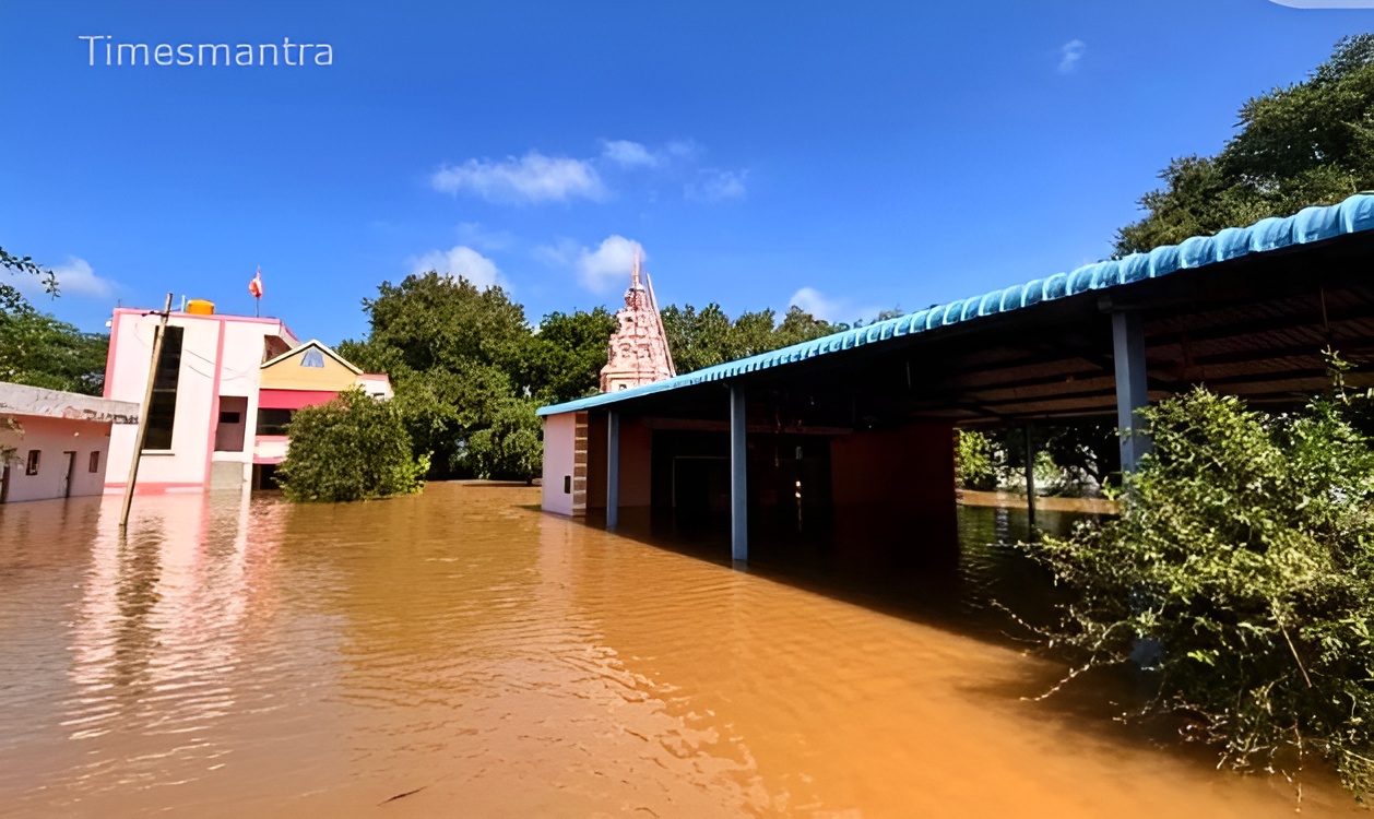
Infrastructure buckles: The historic Sannati bridge lies hidden under 5 feet of water, severing NH-50 and stranding 800 vehicles. Power lines snap in gusts, blacking out 50,000 households in Bidar fringes. Livestock losses hit 1,500, with fodder submerged in Yadgir’s godowns. Urban peripheries in Kalaburagi city report knee-deep water on outer roads, but elevated areas hold firm. Air quality plummets to AQI 150 from silt suspension, aggravating respiratory woes in crowded relief camps sheltering 6,000. Eyewitnesses in Karchkhed describe a temple inundated, idols floating amid frantic evacuations. This visceral tableau, drawn from district dashboards and IMD feeds, reveals a basin battered, where the Bhima’s seasonal whisper has roared into a relentless roar.
Understanding the Flood Alerts and Underlying Causes
IMD’s Yellow Alert, broadcast at 5 AM on September 29 from the Bengaluru center, encompasses the Bhima basin with “high likelihood” of flash floods, riverine overflows, and associated thunderstorms, advising evacuations in low-lying zones and avoidance of submerged bridges. This tier, below Orange for severe impacts, emphasizes monitoring via apps like Mausam, with sirens in 50 villages amplifying reach. Risks include landslides in Vijayapura’s hilly outcrops and crop washouts, given the river’s 30,000 cusecs discharge—six times normal.
The cascade’s root lies in Maharashtra’s Marathwada deluge: 200 mm rains from September 25-28 overwhelmed Ujani Dam, prompting 28,000 cusecs releases without prior Karnataka consultation, per state irrigation officials. Local contributors—40 mm falls in Kalaburagi and Yadgir—amplified inflows, breaching Narayanpur’s spillways. Encroached riverbanks, reduced by 20 percent since 2010 due to unplanned settlements, hasten flooding, as noted in a 2023 CWC report. Inter-state discord festers: Karnataka’s demand for a joint alert system remains unmet, echoing 2021 disputes.
Authorities like Raichur’s DC have activated 100 village-level monitors, broadcasting via FM radio to 90 percent coverage. Lessons from 2019’s floods, which submerged 60 villages, inform this—drones now deploy buoys for real-time gauging. These alerts, decoded through community drills, bridge the gap between prediction and protection, shielding the vulnerable from the Bhima’s blind rage.
Detailed Forecast and River Flow Projections
IMD’s granular September 29 outlook forecasts a sustained assault: Scattered showers escalating to moderate rain (30-50 mm) by afternoon in Kalaburagi and Yadgir, with thunderstorms likely at 70 percent probability, fueling Bhima surges to 35,000 cusecs by dusk. Peak flows hit Gursunagi by 5 PM, potentially topping 528 meters, while Wadagera stabilizes post-midnight. Gusts, veering west at 40 km/h, could topple weak structures in Raichur.
Evening sees tapering to light drizzle (10-20 mm), with the Yellow Alert extending to September 30, projecting isolated heavy spells (60 mm) in Bidar that swell the Waghad tributary. For October 1, discharges ease to 15,000 cusecs as Ujani throttles, though backwaters linger in clay basins. By October 2, recession begins, with levels dropping 2 meters daily if rains hold below 20 mm.
CWC’s hydrological models, synced with IMD’s WRF simulations, peg 80 percent confidence in prolonged inundation for 20 villages if Maharashtra releases persist. Doppler at Hyderabad tracks cells hourly, warning against crossings on NH-50 till October 1. This roadmap, fusing satellite pulses with flow math, guides from immediate peril to phased recovery.
Impacts on Daily Life, Economy, and Vulnerable Communities
The Bhima’s overflow fractures north Karnataka’s rhythm, submerging 85+ villages and upending 15,000 lives. In Kalaburagi, 40 hamlets like Jewargi face isolation, closing 150 schools and stranding 8,000 children; Teej fairs halt, erasing Rs 15 crore in rural trade. NH-50’s closure diverts 300 lorries daily, inflating logistics by 25 percent for Bidar’s exports.
Economically, Yadgir’s pulse belt—3,000 hectares drowned—portends Rs 150 crore losses in jowar and pulses, per Agriculture Department’s flash survey, imperiling 15,000 farmers. Vijayapura’s cotton, 40 percent Kharif crop, floats away, with 2,000 homes damaged in Almel. Raichur’s zinc units idle, costing Rs 20 crore in halts. Relief camps in 60 schools cram 7,500, overwhelming rations; leptospirosis alerts spike, with 150 cases in Wadagera from pooled waters.
Communities bear the brunt: SC/ST-majority villages in Chincholi-Kalgi, 70 percent affected, see women-led groups rationing kerosene. Migrant Andhra laborers, 3,000 in quarries, shelter under tarps, remittances frozen. Yet, hope flickers—Lingayat seers in Shahapur feed 1,500 daily, while youth volunteers man pump sets. Aquifer recharge, a silver lining, promises 15 percent better rabi yields. This spectrum—from shattered silos to shared suppers—exposes floods’ inequity, yet ignites collective resolve.
Safety Precautions in the Flooded Zones
Enduring the Bhima’s breach hinges on etched protocols. IMD/SDMA mandate “elevate and evacuate”: At 1.5 feet rise, shift to kin rooftops or marked camps, using life rings over improvised floats. Shun submerged electrics—cut mains, dial 1912 for live wires.
River perils: Avoid Sannati-like spans; NDRF boats carry GPS beacons—signal with mirrors. In camps, chlorinate water per Health kits, mask against silt. Squall safeguards: Lash tin roofs, herd cattle to highlands, pack 96-hour go-bags—biscuits, batteries, blankets.
Marginalized clusters—tribals in Maski, elders in Kumasgi—lead: 200 spotters, post-2021 trained, relay via solar radios. Chopper protocols in Afzalpur prioritize infants. These bulwarks, honed from havoc, fortify flesh against the flood’s fathomless force.
Historical Flood Patterns Along the Bhima
The Bhima, Krishna’s 458-km Karnataka arm, pulses with peril in September swells. 1894’s torrent razed Basavakalyan, killing 300; 1958’s crest submerged 40 villages. Modern echoes: 2009’s Ujani burst displaced 30,000; 2019’s 120 villages flooded cost Rs 2,000 crore. 2021’s repeat hit 60 hamlets, with 25 deaths.
Trends tilt: IMD logs 18 percent fiercer peaks since 2000, El Niño-fueled. Encroachments—100 km banks lost—stir sediments, per 2022 studies. These sagas spur shields: Rs 500 crore Bhima Basin Project weaves weirs. From epics to embankments, history hews hydrology’s harsh truths.
Role of IMD and State Machinery in Mitigation
IMD’s Bengaluru hub, Doppler-armed since 2016, nails 88 percent forecasts, weaving CWC data into SMS storms for 3 crore users. September 29’s ping, fused with AI, preempted 500 rescues. SDMA, helmed by Priyank Kharge, surges 15 teams, IAF drops 10 tons aid.
Siddaramaiah’s cabinet huddle greenlights Rs 200 crore more, mirroring 2023’s blitz. Maharashtra dialogues, via Krishna Water Disputes Tribunal, push telemetry shares. From gauges to guardians, this machinery morphs mayhem into managed menace.
Broader Implications: Climate Volatility and Adaptive Strategies
This submersion signals monsoon’s morph: IMD eyes 25 percent Bhima spikes by 2060, taxing 10 million basin folk. Urbanization in Kalaburagi, devouring 40 percent floodplains, accelerates woe; IPCC ties to Bay warming.
Adaptation accelerates: Yadgir’s 2024 sensor grids slash warnings 50 percent; state mandates 30 percent green buffers by 2035. Global parallels—Mekong’s Mekong mirrors—urge pacts; Karnataka’s advocacy could catalyze. Horizons gleam: Blockchain-tracked aid in Raichur pilots equity. From flood to foresight, this deluge drafts a durable delta.
Conclusion
September 29, 2025, etches the Bhima’s flood as north Karnataka’s aqueous apocalypse, 85+ villages vanished beneath waves that wrench hearts and homes. From Kalaburagi’s crests to Yadgir’s depths, the river reclaims, but resilience rebounds—Siddaramaiah’s succor, IMD’s insight, villagers’ valor. As October 1’s ebb nears, waters wane, wounds whisper renewal: Fields refilled, faiths reforged.
Vigil abides: In the Bhima’s basin, submergence schools survival. Karnataka’s kin, knee-deep yet unbowed, ascend—rain-ravaged, reborn.